So Long, Old Town
Click here to book tickets for THE GENTLE AUTHOR’S TOUR OF SPITALFIELDS on New Year’s Day.

Francis in the role of Newsvendor.
Favourite clothing company, OLD TOWN, run by Marie Willey and Will Brown is closing after twenty-two years of supplying clothes by mail order from their shop in Holt, Norfolk.
As a tribute, I publish my account of my pilgrimage to Holt in spring 201o to collect a pair of tweed trousers, but perhaps the real tribute is that I am still wearing them all these years later. The story is complimented with a set of photographs of Old Town clothes by Scott Wishart under the title ‘Old Town Small Trades.’
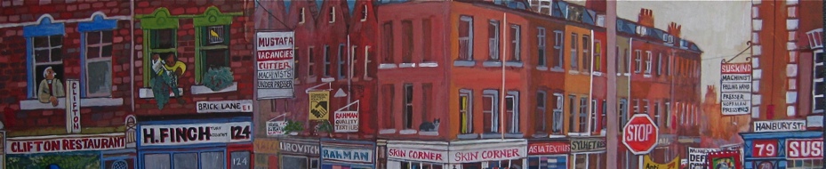
If you remember your Chaucer, you will know that April is the time to go on pilgrimages. So, I decided to seize the opportunity of the spring weather to make a pilgrimage to Old Town to collect my trousers that I ordered. Taking the train from Liverpool St up to Sheringham, I walked five miles over the hills to Holt, a small town that exemplifies the term quaint. Here in Bull St, next to the fishmonger and the butcher was my destination.
On this dreamy afternoon, there were bluebells in the woods and rabbits in the hedges as I walked along lanes through attractive villages with fine churches built of flint, to arrive in Holt where second-hand bookshops and antique shops filled with Staffordshire figures beckoned. But my thought was only of trousers, and this kept my wayward footsteps directed upon the straight path that led directly to Bull St.
I rang the bell and Miss Willey descended the narrow staircase to welcome me into the shop. Once I saw all the clothes, I wanted to try on everything at once, but first Marie ushered me upstairs to have cup of tea and say “Hello” to Will Brown, who was working in the room above, cutting cloth. He was preparing all the pieces that make up each garment, ready for collection by the half-dozen machinists who sew the clothes together at home and deliver them back for Will to add the finishing touches later in the week.
With remarkable strength of mind, Marie & Will work here in two small rooms above their shop in this remote corner of Norfolk making their heart-warming clothes, and, as a result, this cottage industry works at peak capacity, selling as much as they can produce. Their unlikely success is a testament to their hard work and perseverance over all this time, pursuing the distinctive vein of workwear that is their forte and which has established them as pre-eminent in the field. Designers from Levis and Burberry sneak up to Norfolk to get a feeling for what is going on and attempt to incorporate it, but while trends ebb and flow, clothes from Old Town are classics that never go out of fashion.
Informed by his knowledge of work clothes over the last century, Will Brown’s designs are not reproductions of vintage or in the style of any single period, they are a synthesis. Using mostly British fabrics, every single garment is made to order with rigorous quality control – because Marie & Will personally ensure that everything is done beautifully. Their clothes are functional without being mundane, elegant without being demonstrative, and lacking in unnecessary details while at the same time possessing good details. You can wear them everyday. Neither posh, nor bohemian, nor nerdy, they exude a levity that defies categorisation. This is the genius of Old Town.
As I sipped my tea, Marie & Will chatted as they worked, without ceasing from the job in hand, inhabiting a moment of constant amused animation, moving from one task the next and doing each thing properly. Marie was answering the phone, wrapping up parcels perfectly in brown paper and pressing clothes with a steam iron – all in a room barely six-foot square – and running downstairs to customers in the shop. As a couple, Marie & Will complement each other naturally. While Marie is flitting up and downstairs, holding it all together with indefatigable buoyancy, Will quietly works at the cutting table with efficient calm and gravity. You could say it is all a kind of performance, but you could equally say it is a lot of hard work too. The singular life they have created for themselves and the clothes they make are inseparable, and to their many appreciative customers, Marie & Will are the quiet heroes of drill and twill.
Once I had finished my cup of tea, Marie placed my newly made pair of brown tweed trousers upon the cutting table with discreet pride and I carried them downstairs to the empty shop where, all alone in a back room, I tried them on. The tweed was soft and light, with a pale brown cotton lining, bone buttons and the most beautifully embroidered button holes I ever saw. Pulling them on, my legs seemed to grow longer and as I pulled them up around my waist, I lifted my head to stand up straighter. Once they were buttoned, I pushed my hands into the pockets for the first time and raised my eyes to the mirror to admire the effect. Although these were my first pair of Old Town trousers, the effect was curiously familiar. They fitted perfectly and the design was such a masterpiece of understatement that I was at home in them at once.
Before I set out for the bus stop, Marie packed my trousers into a flat cardboard box that, if it were under a Christmas tree, would create the expectation of a doll’s tea set or a model railway inside. Striding across the town square with the magic box under my arm, I was grateful to Marie & Will, not only for my wonderful tweed trousers, but also because thanks to Old Town – even in spring – I always have a reason to look forward to winter.

Sonia in the role of Archivist at the Department of Circumlocution

Jim in the role of Carpenter.

Harvey in the role of Waiter.

Twins Lee & Lisa in the role of Housekeepers.

Chris in the role of Costermonger.

Miss Willey and Old Brown in the role of Tea Stall Proprietors.

Izzy in the role of Flower Girl.

Barry in the role of Barber.

Bommer & Appleton in the role of Piano Movers.
Photographs copyright © Old Town
Viscountess Boudica’s Christmas
Our dearly beloved Viscountess Boudica was evicted from her flat in Bethnal Green in 2016 and moved to Uttoxeter, be we still remember her fondly every Christmas.

Let it be said that if anyone in the East End knew how to keep the spirit of Christmas, it was the Viscountess Boudica of Bethnal Green. At this time of year, her tiny flat near Columbia Rd was transformed into a secret Winter Wonderland where the visitor might forget the chill of the gloomy streets outside and enter a realm of magic, fantasy and romance in which the Viscountess held court like a benevolent sprite or fairy godmother, celebrating the season of goodwill in her own inimitable style.
Boudica had already been at work for weeks when I arrived with my camera to capture the Christmas spectacle for your delight, yet she was still putting the finishing touches to her display even as I walked through the door. “You see these bells?” she said, reaching up to add them to the colourful forest of paper decorations suspended from the ceiling, “I bought them in Woolworths in Tottenham for 45p in 1984. When I think of all the people they have looked down upon – if only these bells could talk, they’ve seen it all!”
Evidence of the season was apparent wherever I turned my eyes, from the illuminated coloured trees that filled each corner – giving the impression that the room was actually a woodland glade – to the table where Boudica was wrapping her gifts and writing cards, to the corner where a stack of festive records awaited her selection, to the innumerable Christmas knick-knacks and figures that crowded every surface, and the light-up reindeer outside in the garden, glimpsed discreetly through the net curtains. “This is thirty years worth of collecting,” she explained, gesturing to the magnificent display enfolding us, “that set of lights is older than I am.”
In common with many, this is an equivocal time for Viscountess Boudica who does not have happy childhood memories of Christmas. “It was hell,” she admitted to me frankly, “We didn’t have any money to buy presents and, in our family, Christmas was always when fights and arguments would break out. The reason I have so many decorations now is to make up for all the years when I didn’t have any.” Yet Boudica remembers small acts of kindness too. “The local shops used to save me their balloons and give me scraps of fabric that I used to make clothes for the kittens in the barn – and that was the beginning of me making my own outfits,” she recalled fondly.
“People should remember what it’s all about,” Boudica assured me, linking her own childhood with the Christian narrative, “It’s about a little boy who didn’t have a home. They should think of others and remember there’s poor people here in Bethnal Green.” Naturally, I asked the Viscountess if she had a Christmas message for the world and, without a second thought, she came to back to me with her declaration – “Be kind to each other and get rid of discrimination!”


Boudica contemplates her Christmas listening – will it be Andy Williams or Jim Reeves this year?

“Whenever I hang up these bells, I think of all the people they have looked down upon over the years”


Wrapping up her gifts.


Filling her stocking


Nollaig Shona Dhaoibh!


Drawings copyright © Viscountess Boudica
You may also like to read
Viscountess Boudica’s Domestic Appliances
Viscountess Boudica’s Drawings
Viscountess Boudica’s Halloween
Viscountess Boudica’s Valentine’s Day
The Departure of Viscountess Boudica
Read my original profile of Mark Petty, Trendsetter
and take a look at Mark Petty’s Multicoloured Coats
Old Christmas Baubles

I do not know when my grandmother bought this glass decoration and I cannot ask her because she died more than twenty years ago. All I can do is hang it on my tree and admire it gleaming amongst the deep green boughs, along with all the others that were once hers, or were bought by my parents, or that I have acquired myself, which together form the collection I bring out each year – accepting that not knowing or no longer remembering their origin is part of their charm.
Although I have many that are more elaborate, I especially admire this golden one for its simplicity of form and I like to think its ridged profile derives from the nineteen thirties when my mother was a child, because my grandmother took the art of Christmas decoration very seriously. She would be standing beech leaves in water laced with glycerine in October, pressing them under the carpet in November and then in December arranging the preserved leaves in copper jugs with teazles sprayed gold and branches of larch, as one of many contrivances that she pursued each year to celebrate the season in fastidious style.
Given the fragility of these glass ornaments, it is extraordinary that this particular decoration has survived, since every year there are a few casualties resulting in silvery shards among the needles under the tree. Recognising that a Christmas tree is a tremendous source of amusement for a cat – making great sport out of knocking the baubles to the ground and kicking them around like footballs – I hang the most cherished decorations upon the higher branches. Yet since it is in the natural course of things that some get broken every year and, as I should not wish to inhibit the curiosity of children wishing to handle them, I always buy a couple more each Christmas to preserve the equilibrium of my collection.
Everlasting baubles are available – they do not smash, they bounce – but this shatterproof technological advance entirely lacks the poetry of these fragile beauties that can survive for generations as vessels of emotional memory and then be lost in a moment. In widespread recognition of this essential frailty of existence, there has been a welcome revival of glass ornaments in recent years.
They owe their origins to the glassblowers of the Thuringian Forest on the border of Germany and the Czech Republic where, in Lauscha, glass beads, drinking glasses, flasks, bowls and even glass eyes were manufactured since the twelfth century. The town is favoured to lie in a wooded river valley, providing both the sand and timber required for making glass and in 1847 Hans Greiner – a descendant of his namesake Hans Greiner who set up the glassworks in 1597 with Christoph Muller – began producing ornaments by blowing glass into wooden moulds. The inside of these ornaments was at first coloured to appear silvery with mercury or lead and then later by using a compound of silver nitrate and sugar water. In 1863, when a gas supply became available to the town, glass could be blown thinner without bursting and by the eighteen seventies the factory at Lauscha was exporting tree ornaments throughout Europe and America, signing a deal with F.W.Woolworth in the eighteen eighties, after he discovered them on a trip to Germany.
Bauble is a byword for the inconsequential, so I do not quite know why these small glass decorations inspire so much passion in me, keeping their romance even as other illusions have dissolved. Maybe it is because I collect images that resonate personally? As well as Father Christmas and Snowmen, I have the Sun, Moon and Stars, Clocks and even a Demon to create a shining poem about time, mortality and joy upon my Christmas tree. I cannot resist the allure of these exquisite glass sculptures in old-fashioned designs glinting at dusk amongst the dark needles of fir, because they still retain the power to evoke the rich unassailable magic of Christmas for me.

This pierrot dates from the nineteen eighties

Three of my grandmother’s decorations. The basket on the left has a piece of florists’ wire that she placed there in the nineteen fifties

This snowman is one of the oldest of my grandmother’s collection

Bought in the nineteen eighties, but from a much older mould

Baubles enhanced with painted stripes and glitter

The moon, sun and stars were acquired from a shop in Greenwich Avenue on my first visit to New York in 1990, amazingly they survived the flight home intact


These two from my grandmother’s collection make a fine contrast of colour

Even Christmas has its dark side, this demon usually hangs at the back of the tree

It is always going to be nine o’clock on Christmas Eve

Three new decorations purchased at Columbia Rd

A stash of glittering beauties, stored like rare eggs in cardboard trays

Russian cosmonauts from the sixties that I bought in Spitalfields Market

My first bicycle, that I found under the tree one Christmas and still keep in my attic
The Ghosts Of Old London

Join me for THE GENTLE AUTHOR’S TOUR OF SPITALFIELDS on New Year’s Day

Click to enlarge this photograph
To dispel my disappointment that I cannot rent that Room to Let in Old Aldgate, I find myself returning to scrutinise the collection of pictures taken by the Society for Photographing the Relics of Old London held in the archive at the Bishopsgate Institute. It gives me great pleasure to look closely and see the loaves of bread in the window and read the playbills on the wall in this photograph of a shop in Macclesfield St in 1883. The slow exposures of these photographs included fine detail of inanimate objects, just as they also tended to exclude people who were at work and on the move but, in spite of this, the more I examine these pictures the more inhabited they become.
On the right of this photograph, you see a woman and a boy standing on the step. She has adopted a sprightly pose of self-presentation with a jaunty hand upon the hip, while he looks hunched and ill at ease. But look again, another woman is partially visible, standing in the shop doorway. She has chosen not to be portrayed in the photograph, yet she is also present. Look a third time – click on the photograph above to enlarge it – and you will see a man’s face in the window. He has chosen not to be portrayed in the photograph either, instead he is looking out at the photograph being taken. He is looking at the photographer. He is looking at us, returning our gaze. Like the face at the window pane in “The Turn of the Screw,” he challenges us with his visage. Unlike the boy and the woman on the right, he has not presented himself to the photographer’s lens, he has retained his presence and his power. Although I shall never know who he is, or his relationship to the woman in the doorway, or the nature of their presumed conversation, yet I cannot look at this picture now without seeing him as the central focus of the photograph. He haunts me. He is one of the ghosts of old London.
It is the time of year when I think of ghosts, when shadows linger in old houses and a silent enchantment reigns over the empty streets. Let me be clear, I am not speaking of supernatural agency, I am speaking of the presence of those who are gone. At Christmas, I always remember those who are absent this year, and I put up all the cards previously sent by my mother and father, and other loved ones, in fond remembrance. Similarly, in the world around me, I recall the indicators of those who were here before me, the worn step at the entrance to the former night shelter in Crispin St and the eighteenth century graffiti at the entrance to St Paul’s Cathedral, to give but two examples. And these photographs also provide endless plangent details for contemplation, such as the broken windows and the shabby clothing strung up to dry at the Oxford Arms, both significant indicators of a certain way of life.
To me, these fascinating photographs are doubly haunted. The spaces are haunted by the people who created these environments in the course of their lives, culminating in buildings in which the very fabric evokes the presence of their inhabitants, because many are structures worn out with usage. And equally, the photographs are haunted by the anonymous Londoners who are visible in them, even if their images were incidental to the purpose of these photographs as an architectural record.
The pictures that capture people absorbed in the moment touch me most – like the porter resting his basket at the corner of Friday St – because there is a compelling poetry to these inconsequential glimpses of another age, preserved here for eternity, especially when the buildings themselves have been demolished over a century ago. These fleeting figures, many barely in focus, are the true ghosts of old London and if we can listen, and study the details of their world, they bear authentic witness to our past.

Two girls lurk in the yard behind this old house in the Palace Yard, Lambeth.

A woman turns the corner into Wych St.

A girl watches from a balcony at the Oxford Arms while boys stand in the shadow below.

At the Oxford Arms, 1875.


At the entrance to the Oxford Arms – the Society for Photographing the Relics of Old London was set up to save the Oxford Arms, yet it failed in the endeavour, preserving only this photographic record.

A relaxed gathering in Drury Lane.

A man turns to look back in Drury Lane, 1876.

At the back of St Bartholomew’s, Smithfield, 1877.

In Gray’s Inn Lane.

A man peers from the window of a chemists’ at the corner of Lower James St and Brewer St.

A lone policeman on duty in High Holborn, 1878.

A gentleman in Barnard’s Inn.

At White Hart Inn yard.

At Queen’s Inn yard.

A woman lingers in front of the butcher in Borough High St, Southwark.

In Aldgate.

A porter puts down his basket in the street at the corner of Cheapside and Friday St.

In Fleet St.

The Old Bell, Holborn

At the corner of Fore St and Milton St.

Doorways on Lawrence Pountney Hill.

A conversation at the entrance to Inner Temple, Fleet St.
Images courtesy Bishopsgate Institute
You can see more pictures from the Society for Photographing the Relics of Old London here In Search of Relics of Old London
On Christmas Day
Click here to join me for THE GENTLE AUTHOR’S TOUR OF SPITALFIELDS on New Year’s Day
It has become a tradition to publish this story at Christmas each year.

Over successive Christmases, as I was growing up in Devon, I witnessed the disintegration of my family until today I am the lone survivor of the entire clan, the custodian, charged with carrying the legacy of all their stories. Where once I was the innocent child in the midst of a family drama unknown to me, now I am a sober adult haunted by equivocal memories of a conflict that only met its resolution in death. Yet in spite of this, whenever I examine the piles of old photographs of happy, smiling people which are now the slim evidence of the existence of those generations which precede me, I cannot resist tender feelings towards them all.
I was an only child and, though I wished for playfellows occasionally, I do not regret my childhood solitude because the necessity to invent my own amusement gave me my life as a writer. Since there were just the three of us, I had quite separate relationships with my mother and my father, and I never perceived us as a family unit. My father’s parents and my mother’s father died before I was born, and so it was only when we went to visit my grandmother at Christmas that we were forced to confront our identity as part of a larger tribe.
Even the journey to my grandmother’s house, a mere forty minute drive over the hills, was fraught with hazard. As I lay in bed surrounded by my presents newly-unwrapped on Christmas morning, I could hear my parents in the kitchen below discussing which was the greater risk – of skidding on black ice on the upland roads or getting washed away in floods surging down the valleys. Though, throughout my entire childhood, we never encountered any mishap on this journey, even if the emotional dangers of the visit were immense.
In the week before Christmas, my mother would have her hair ‘done’ in hope of passing her mother’s inspection on Christmas Day and as we climbed into the car, even as she closed the door, she would be checking in the mirror and repeatedly asking, “Do you think my hair looks alright?” Complementing my mother’s worry over her hair was my father’s anxiety over his engine. As the owner of a series of secondhand wrecks bought on the cheap, he was reluctant to undertake any journey that involved an incline, which proved to be something of a problem in Devon. Consequently, journeys of more than a few miles were uncommon in my childhood and our rare summer holidays were taken at seaside resorts less than twenty miles from home.
While my parents sat consumed by silent dread in the front of the car on Christmas morning, I was naively entranced by the passing landscape, with its bare fields sparkling in the frost or puddled by rain, and the old cottages punctuating the hedgerows. Over the years, I grew to know this journey intimately and experienced a child’s delight in the transformation wrought upon the landscape by the changing seasons. Yet the final steep descent into the small town of old stone buildings where my grandmother lived was always accompanied by a corresponding rise in tension. My father’s palpable anxiety about black ice coinciding precisely with the approaching ordeal. Invariably, we arrived as late as he could manage and, parking in the yard in the back of my grandmother’s house, pass through the wooden garden gate and walk slowly down the path in trepidation to arrive at the kitchen door.
Inside the house, my grandmother would be discovered at the scrubbed wooden table, beating something vigorously in a mixing bowl, smoking a cigarette and still dressed in the fur coat and velvet turban she wore to church that morning. One memorable Christmas, she cast down her wooden spoon as we entered. “You look a fright, Valerie! What have you done to your hair?” she exclaimed, advancing and running her fingers through my mother’s hair to dishevel it. My mother ran through the hallway, up the stairs and along the passage to lock herself into the bathroom, as she re-entered the emotional drama of her childhood in the place where she had grown up.
It was the last house in the town, a late-Victorian villa at the end of a line with only fields beyond, and I was entranced by its gothic architecture. The stained glass porch with colourful encaustic tiles was the threshold to a dwelling which contained mysteries from the years before I came into the world. This was an effect compounded by the hallway, with its ancient grandfather clock whose chimes conjured an atmosphere of stately gloom and dark wooden staircase ascending in a spiral to the upper rooms where the ghosts of the past dwelled. Halfway up the stair hung an old oil painting in a gold frame of sailboats emerging from the mist like apparitions coalescing from the miasma of time. Yet even this also contained a mystery of its own, since I was led to understand that there was another painting that might be discerned beneath this nineteenth century nautical scene, which had been overpainted upon a seventeenth century Dutch interior.
Dominating the hallway at Christmas was my grandmother’s spectacular annual display. Each December, she arranged winter foliage in a gleaming copper jug upon the oak hall table as the climax of her year’s endeavours in competitive flower-arranging. When the carpet crunched beneath my footstep once, I lifted it to find beech twigs pressed between sheets of The Daily Telegraph. My discovery occasioned a complex explanation of the alchemical magic of standing beech branches in jars of glycerine to preserve the leaves which might then be flattened beneath the carpet until November, when they could be sprayed gold to serve as the flourish in my grandmother’s festive arrangement of holly, scots pine, ivy, and Christmas Roses.
Of equal fascination to me were these Christmas ‘roses’ which were like no other roses I had ever seen and grew close to the ground beside an old wall in my grandmother’s garden. With their curious, pale wax-like petals which came into flower when all the other plants died away, I believed they were unique to her and their extraordinary qualities were an expression of her mastery of nature itself.
My grandmother occupied a prominent position within her immediate community. It was a status that was confirmed when she undertook the role of Elizabeth I, enthroned upon a float in the town carnival, outfitted in a starched lace ruff and a dress of embroidered velvet and satin spangled with pearls. The other members of the Women’s Institute dutifully enacted the supporting roles of ladies in waiting, clad in second rate outfits and offering obeisance to their omnipotent monarch.
Naturally, she had conscientious reasons for wrecking her daughter’s hairstyle that Christmas morning. The act was an expression of the burden of responsibility that fell upon her and she could not avoid it. She had been brought up to be particular, educated into the expectations that are the birthright of the privileged, and she wore her fastidiousness as a badge of honour. As the youngest daughter of a declining aristocratic family without any inheritance, my grandmother gamely overcame the obvious disappointment in her marriage to a bank manager and still hoped to reassert the fortunes of her noble line by marrying my mother off to local land-owning gentry. She felt it had been churlish of her daughter not to co-operate.
Yet my mother’s most cherished possession was a copy of Cicely M. Barker’s ‘Book of the Flower Fairies,’ inscribed by my grandfather “To the little girl who loves all the wild flowers” and she dreamed of going to university to study Botany. She had no interest in cultivating the attentions of boorish yeoman farmers. Instead she escaped, climbing over a wall with her suitcase at night and fleeing from the typing and secretarial college where she had been sent when the possibility of higher education had been denied her. Running away to the nearest market town, she took a room in a lodging house, found employment at the local library and married my father, who was the handsome centre-forward in the city football team and worked as an engineer at a foundry.
Consequently, my mother’s marriage was the death of my grandmother’s social aspirations. And since my grandfather gave up his position as a bank manager to go on the stage, pursuing an energetic career as a conjurer in vaudeville that led him to an early grave, she became a lone sentinel of her class. Mercifully, the bank granted her the right to stay in the house that he had rented from them on favourable terms, leaving her domestically secure yet struggling to keep up appearances for the rest of her days.
She displayed no photographs of my mother or my father or me anywhere lest visiting Rotarians might see them, but once a year she invited us over at Christmas as an act of Christian charity, thereby ameliorating her own sense of loss. The truth was that, even in relation to my grandmother’s straightened circumstances, we were the poor relations. My father laid out the bills next to his pay packet each week and often wept in helpless anger when his meagre earnings as a mechanical engineer were insufficient to cover our modest living expenses. One day, I came home from school for lunch only to discover my mother in despair because her housekeeping money had run out and we had nothing to eat. Yet at Christmas, we wore the best clothes we had and, maintaining solidarity, did our best to keep up appearances and resist my grandmother’s insinuations.
Once emotions had subsided and I had persuaded my tearful mother from the bathroom, we all convened in the drawing room for an aperitif. My Uncle Richard would be arriving back from the pub full of cheery good humour after drinks with his friends in the amateur dramatics and the cricket club. Seizing this moment to light another cigarette, “Would you like a glass of sherry?” my grandmother announced, filling with sudden enthusiasm, before adding with a significant glance in my father’s direction, “I think I have bottle of beer for Peter.” Reminding us of her impoverishment since the early death of my grandfather who indulged her aristocratic spending capacities, “We’ve had to cut back this year, I haven’t been able to do as much as I normally do,” my grandmother always informed us, catching my eye to indicate that I should not expect much from her. With saintly self-control, my father would open a newspaper with a sigh and take a seat by the fire, doing his best to maintain dignified silence in the face of this humiliation.
It was my grandmother’s custom to deliver her turkey to the baker on her way to church on Christmas morning and collect it again after the service, almost roasted, so that she could finish it off in the oven at home, thus permitting her to give full attention to the serious business of vegetables and, of course, the pudding. Shedding her fur coat when it came to moment of serving, she nevertheless maintained her hauteur in a well cut tweed skirt, silk blouse, pearls and crocodile court shoes, with only the addition of an apron casually slung around her waist to indicate her culinary responsibilities.
My uncle sat at the far end of the table, facing my grandmother at the head, while my mother and father sat together on one side and I sat opposite them beneath a mezzotint of Jean-François Millet’s ‘The Angelus.’ I sometimes wondered if this sombre image of a pair of down-trodden peasants praying in a field reflected my grandmother’s perception of my parents’ life. When I gazed across the table, I could see my mother sitting under a print of George Frederic Watts’ ‘Hope,’ depicting a blindfolded woman trapped on a rock in a rising tide while plucking upon the single string left on her makeshift harp. In spite of their obvious sentimentality, both of these pictures demonstrated stoic attitudes in the face of adversity which suited my grandmother’s temperament and circumstances.
Placing her cigarette carefully between her pursed lips, she leaned forward with intense short-sighted concentration to slice the turkey on the table in front of her. We each passed up our plates and, when it came my father’s turn, she would cast her eyes down the table to him and my uncle would catch her eye before reaching out to give him a playful shove. “Are you a breast or a leg man, Peter?” he asked with a chuckle and a lewd grin. This annually repeated gesture was a source of enormous amusement for him and my grandmother, but a cause of deep embarrassment for me and my mother and father.
I can only assume this jibe was a reference to my father’s supposed sexual prowess, as the only possible explanation they could entertain for my mother’s attraction to a man beneath her class. They did not wish to appreciate that my mother’s curiosity about life beyond their limited social milieu had opened her eyes to recognise sympathetic qualities in people of all kinds, rather than simply to assess the social status of new acquaintances.
It was only after my father’s death that I discovered he had been born as the illegitimate child of a young housemaid who contracted tuberculosis and had no choice but to give him up for adoption. Then, at the tender age of just eleven years old, denied a proper education, he was put to work in a foundry. As an adult, his disadvantaged origins were such a source of shame that he chose never to reveal the truth even to my mother.
Among his own mother’s surviving letters that I found preserved in a padlocked box I broke open after his death, I read her account of being committed to a sanatorium on Dartmoor where patients were exposed to the elements in a belief this treatment could clear their lungs of infection. “I don’t think I shall be home for Christmas. Must tell you it is a bitter cold place here in winter. We sleep out in the open, and when it rains it comes right in and you are not allowed to shut any doors and the wind nearly blows you out of bed,” she wrote in an unlettered cursive hand.
When I read these letters, I wondered if her words from so long ago haunted my father at these Christmas feasts. “I don’t know what sort of Christmas they spend here,” she confided in a note written from the sanatorium in the months before her death, “Have you made your Christmas pudding yet? I hope you will send me a little bit to taste. It will seem more like a Christmas to me if I can taste a bit of pudding.”
Accompanying the letters was my father’s birth certificate, confirming his father as ‘unknown.’ This single word contained a personal tragedy which grew into a lonely secret. His desire to overcome this deep sense of shame became a motivating factor which led him to marry my mother. Just as she wanted to escape the pretensions of her family, he wanted to better himself by taking a step up in the world. In this sense they fulfilled each other’s desires perfectly, even if they wanted quite different things from the union and their contrary wishes were a source of occasional conflict. This was the nature of their marriage.
“I always wanted to be a close family,” he confided to me once in a moment of weary confession, “but they weren’t having it.”
After my grandmother had carried in the flaming pudding, the crackers had exploded and my mother had done the washing up, we were able to escape the house for an afternoon walk through the cool air in the damp lanes to recover our senses. Returning for tea at dusk, I would take this opportunity to slip away from the fireside, leaving the adults to their conversation and climbing the staircase to explore the dusty attics at the top where my grandfather’s stage properties and conjuring tricks were stored. In these chilly abandoned rooms, I discovered a wind up gramophone and was happy to wear his silk top hat and play alone among the mirrored cabinets until it was time to leave.
As a child, I was spared the pain that my parents endured when confronted with the social disparity of their marriage by my grandmother. “None of these people have ever worked a day in their lives,” my father repeated to us in the car, every year on the way home, venting his vituperation at last and drawing further tears from my mother. In spite of the tensions of the day, she was always reluctant to leave her childhood home that held so many happy memories buried beneath the recent conflict.
On one of the last Christmases before my grandmother died, when I returned for the holiday from college, she insisted that I play her at Scrabble. It was already late in the day. We had had our tea and cut the Christmas cake, and we were preparing to leave. My father, who hated driving in the dark, was getting worried about the possibility of lethal black ice on the upland roads. Yet I knew my mother realised that this was a challenge I must not walk away from, even though my grandmother was county Scrabble champion of several years standing. She had memorised all the obscure yet permitted words, using unlikely letters and winning high scores. At eighty years old, she needed to prove her mind was still as sharp as a razor and she wanted to find out what I was made of too. It was a rite of passage.
Once my grandmother and I were set up on opposite sides of the dining table with the Scrabble board between us, my parents retreated to the drawing room in silence, unable to bear their suspense at the outcome. Although my grandmother generously offered to share her list of permitted words with me, I declined. I did not want her help. By now, I knew the weight of history. In fact, I would not even compete with her. Instead I chose to apply my creativity to contrive the most ingenious words I could make with my letters, without pursuing a high-scoring vocabulary or keeping an eye on the score card total. Although I knew it was a test, I persisted in the thought that it was a Christmas game.
I won. My mother and father entered and stood in the doorway with blazing eyes of unspoken elation. Withholding her emotion and describing it as ‘beginners’ luck,’ my grandmother commenced another game immediately. I maintained my non-competitive strategy while she played to win. This time, my grandmother won. Yet when we added up our scores in both games, which ran into hundreds, we discovered we had both won exactly the same number of points.
It was a strange moment of intimacy and mutual vindication. A certain truth had been revealed by Scrabble, even if it was an epiphany capable of entirely contradictory interpretations. My grandmother believed it confirmed that, in spite of my mother marrying my father, the family spirit persisted in me, while my parents believed she had been taught a lesson and could not look down upon us any more.
My uncle never left his childhood home or, to my knowledge, ever formed any significant emotional relationships beyond his immediate domestic world. Brought up with aristocratic expectations, he was a dilettante who stood apart from life, never working but passing his time in amateur dramatics, county cricket scoring and collecting jazz records. He suffered from meningitis as a child and my grandmother doted on him, favouring him over her daughter. She waited upon him until she died, knocked over by a swinging coal house door one dark winter’s night shortly before Christmas when she was eighty-four.
At the funeral in January, my uncle asked my mother, “Would you like to take anything, Valerie?” Eschewing the valuables in the house, she found a trowel and unearthed the cherished Christmas Rose, transplanting it to her own garden where she nurtured it as a living memento of her mother.
After the death of my grandmother, my uncle was left to fend for himself. He did not know how to make a bed or boil a kettle and he let the house go to pieces. He ate only microwaved frozen food and grew so fat that he could not bend over to reach the floor, living ankle deep in rubbish. The last time I visited, I discovered he had worn a path in the carpet through to the floorboards in the drawing room between his armchair and the television. Meanwhile upstairs, in his room on the first floor, he had worn the mattress through to the springs and, entering the next room, I found he had done the same in there too and in the next.
I remember telephoning him to break the news that my father had died. “Well, I never did like Peter,” was his immediate response. Eventually, an organised gang of thieves broke in and stripped the house – when he could no longer get out of bed – and he lay there helpless as they carried the silver, the grandfather clock, the old Dutch painting and the rest of the family heirlooms out to the truck.
There was only one childhood Christmas when we did not visit my grandmother. It was the year that a particularly virulent form of gastroentiritis struck. My mother, my father and me, we were all afflicted with flu and lay in our beds on Christmas Day, engulfed by fever and drowsy light-headedness engendered by lack of food. I recall lying awake with my cat in the half-light of drawn curtains, clutching a hot water bottle, and feeling overwhelmed by the weary languor of my body. Yet at three in the afternoon, we convened in the kitchen in our dressing gowns and we drank a cup of hot water together. I think it was the sweetest drink I ever tasted and I cherish the memory of that day, isolated together in our intimate cell of sickness, as my happiest childhood Christmas.
As years pass, each Christmas conjures the memories of those that came before it, until eventually the experience of recalling these memories of the past overtakes the present. Then Christmas becomes a time which contains all the former Christmases gone by. Apart from my flu Christmas, I can barely distinguish any particular years and, looking back, all those visits to my grandmother blend into the one eternal childhood Christmas which I have described here.
When I grew up and left home, I always returned for Christmas. Now that I live in the city and no longer have any relatives left alive, I have no family obligations at Christmas and I have no reason go back to Devon. Yet I miss them all, I even feel nostalgic about their fights and their angry words and I cannot resist the feeling they are all still there – my parents in their house, and my grandmother and my uncle in their house – and I wonder if they are having Christmas without me this year.

Wood Engravings by Reynolds Stone
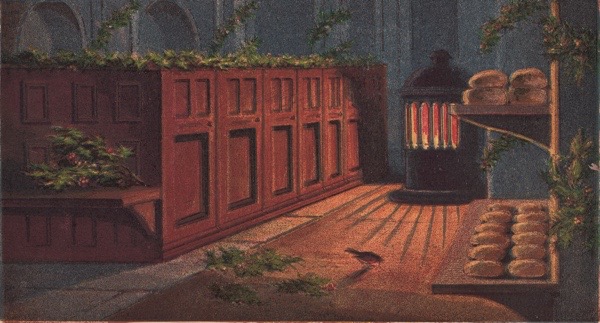
The Robin’s Christmas Eve
This extract is from ‘Aunt Louisa’s Keepsake’ published by Frederick Warne which was given to me by Libby Hall. The copy is inscribed ‘Christmas 1896’ inside the front cover.

‘Twas Christmas-time, a dreary night,
The snow fell thick and fast,
And o’er the country swept the wind,
A keen and wintry blast.

The Robin early went to bed,
Puffed up just like a ball,
He slept all night on one small leg,
Yet managed not to fall.
No food had touched his beak,
And not a chance had he
Of ever touching food again,
As far as he could see.

The stove had not burnt very low,
But still was warm and bright,
And round the spot whereon it stood,
Threw forth a cheerful light.
Now Robin from a corner hopped,
Within the fire’s light.
Shivering and cold, it was to him
A most enchanting sight.
But he is almost starved, poor bird!
Food he must have, or die,
Unless it seems, alas! for that
Within these walls to try.
Perhaps ‘t is thought by those who read
To doubtful to be true,
That just when they were wanted so
Some hand should bread crumbs strew.
But this is how it came to pass,
An ancient dame had said,
Her legacy unto the poor
Should all be spent on bread.
Enough there was for quite a feast,
Robin was glad to find.
The hungry fellow ate them all,
Nor left one crumb behind.


You may also like to take a look at
At Smithfield On Christmas Eve
Carnivorous readers will be delighting to learn that – despite the announcement of closure – the traditional Smithfield Christmas Eve meat auction runs this year hosted by G Lawrence & Co on Grand Avenue in the Central Market from 10am. Blow you can read my account of a visit there with the late photographer Colin O’Brien.

The carnivores of London converged upon Smithfield Market, as they do every year for the annual Christmas Eve auction staged by Harts the Butcher. At ten in the morning, the rainy streets were almost empty yet, as I came through Smithfield, butchers in white overalls were wheeling precarious trolleys top-heavy with meat and fowls over to the site of the auction where an expectant crowd of around a hundred had gathered, anxiously clutching wads of banknotes in one hand and bags to carry off their prospective haul in the other.
Photographer Colin O’Brien met me there. He grew up half a mile away in Clerkenwell during the nineteen fifties and, although it was his first time at the auction, he remembered his father walking down to Smithfield to get a cheap turkey on Christmas Eve more than sixty years ago. Overhearing this reminiscence, a robust woman standing next to us in the crowd struck up a conversation as a means to relieve the growing tension before the start of the auction which is the highlight of the entire year for many of stalwarts that have been coming for decades.
“You can almost guarantee getting a turkey,” she reassured us with the authority of experience, revealing she had been in attendance for fifteen successive years. Then, growing visibly excited as a thought came into her mind, “Last year, I got thirty kilos of sirloin steak for free – I tossed for it!”, she confided to us, turning unexpectedly flirtatious. Colin and I stood in silent wonder at her good fortune with meat.“We start preparing in October by eating all the meat in the freezer,” she explained, to clarify the situation. “Last night we had steak,” she continued, rubbing her hands in gleeful anticipation, “and steak again tonight.”
Yet our acquaintance was terminated as quickly as it began when the caller appeared in a blood-stained white coat and red tie to introduce the auction. A stubby bullet-headed man, he raised his hands graciously to quell the crowd. “This is a proper English tradition,” he announced, “it has been going on for the last five hundred years. And I’m going to make sure everybody goes away with something and I’m here to take your money.”
His words drew an appreciative roar from the crowd as dozens of eager hands were thrust in the air waving banknotes, indicative of the collective blood lust that gripped the assembly. Standing there in the midst of the excitement, I realised that the sound I could hear was an echo. It was a reverberation of the famously uproarious Bartholomew Fair which flourished upon this site from the twelfth century until it was suppressed for public disorder in 1855. Yesterday, the simple word “Hush!” from the caller was enough to suppress the mob as he queried, “What are we going to start with?”
The answer to his question became manifest when several bright pink loins of pork appeared as if by magic in the hatch beside him, held by butchers beneath, and dancing jauntily above the heads of the delighted audience like hand puppets. These English loins of pork were soon dispatched into the crowd at twenty pounds each as the curtain warmer to the pantomime that was to come, followed by joints of beef for a tenner preceding the star attraction of day – the turkeys! – greeted with festive cheers by the hungry revellers. “Mind your heads, turkeys coming over…” warned the butcher as the turkeys in their red wrappers set out crowd-surfing to their grateful prospective owners as the cash was passed hand to hand back to the stand.
It would not be an understatement to say that mass hysteria had overtaken the crowd, yet there was another element to add to the chaos of the day. As the crowd had enlarged, it spilled over into the road with cars and vans weaving their through the overwrought gathering. “I love coming for the adventure of it,” declared one gentleman with hair awry, embracing a side of beef protectively as if it was the love of his life, “Everyone helps one another out here. You pass the money over and there’s no pickpockets.”
After the turkeys came the geese, the loins of lamb, the ribs of beef, the pork bellies, the racks of lamb, the fillet steaks and the green gammon to complete the bill of fare. As the energy rose, butchers began to throw pieces of red meat into the crowd to be caught by their purchasers and it was surreal to watch legs of lamb and even suckling pigs go flying into the tumultuous mass of people. Finally, came tossing for meat where customers had the chance of getting their steaks for free if they guessed the toss correctly, and each winning guess was greeted with an exultant cheer because by then the butchers and the crowd were as one, fellow participants in a boisterous party game.
Just ninety minutes after it began, the auction wrapped up, leaving the crowd to consolidate their proud purchases, tucking the meat and fowls up snugly in suitcases and backpacks to keep them safe until they could be stowed away in the freezer at home. In the disorder, I saw piles of bloody meat stacked on the muddy pavement where people were tripping over them. Yet a sense of fulfilment prevailed, everyone had stocked up for another year – their carnivorous appetites satiated – and they were going home to eat meat.
As I walked back through the narrow City streets, I contemplated the spectacle of the morning. It resembled a Bacchanale or some ancient pagan celebration in which people were liberated to pursue their animal instincts. But then I realised that my thinking was too complicated – it was Christmas I had witnessed.


Photographs copyright © Estate of Colin O’Brien
You might also like to read about


