Adam Dant’s Map of Industrious Shoreditch

Click twice to enlarge and study the details of Industrious Shoreditch
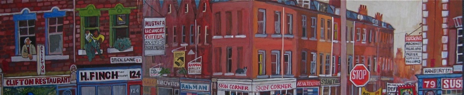
A century before the New Industries that define Shoreditch today, there were once the Old Industries. Then, small manufacturers and their suppliers occupied every building, and the neighbourhood teemed with skilled workers and craftsmen who made things with their hands. Cartographer extraordinaire Adam Dant celebrates this culture with his Map of Industrious Shoreditch, 1912.
“I chose 1912 because it precedes the First World War, when everything changed. It encapsulates Industrious Shoreditch,” explained Adam, “I started off with the major landmarks serving the industries of the time. For the main thoroughfares, I listed the concentrations of manufacturers, using lists of companies from the Post Office Directories. These are complemented by vignettes of people making things, and I filled the border with machines used for wood and metalwork.”
After the First World War, many of the industries moved to larger factories outside London and the twentieth century saw the decline of manufacturing in Shoreditch, with the hardware shops and suppliers of raw materials being the last to go, holding on even into recent decades. Now that Shoreditch is booming again with new technology companies occupying many of the old buildings once used for manufacturing, Adam Dant’s map offers us a poignant opportunity to explore that lost world of industriousness.
You will discover mattress makers, french polishers, feather dyers, hatters, bootmakers, chandlers, over-mantle manufacturers, cabinet makers, coach builders, wood turners, corset makers, and more…


Adam Dant goes in search of Industrious Shoreditch
Map copyright © Adam Dant
You may like to take a look at some of Adam Dant’s other maps
Map of the History of Shoreditch
Map of Shoreditch in the Year 3000
Map of Shoreditch as the Globe
Map of the History of Clerkenwell
Map of the Journey to the Heart of the East End
Map of the History of Rotherhithe

Click here to buy a copy of The Map of Spitalfields Life drawn by Adam Dant with descriptions by The Gentle Author


Mr Dant is one of the most industrious people I know. Another wonderful map.
This is wonderful. How I wish Adam Dant were available to map in his informative, witty and highly personal way every community I have ever known and loved.
If you enjoy Adam’s map you might like to look out for a copy of a book published by English Heritage in 2006 “Behind the Veneer: South Shoreditch – The Furniture Trade and Its Buildings”
My Spitalfields map was well used during my last trip to London. Unfortunately, the street addy for Gardners is wrong. It says it’s at 49 Commercial, which is a lingerie shop! I thought perhaps Paul had branched out. 🙂
Beautiful map, really useful too – been doing some family research and it seems a number if ancestors were French Polishers in the Shoreditch furniture industry. Great stuff!
Fantastic map.
Wonderful.
But no sign of Cleve Workshops I noticed. Anyone know why?
Very special post. Anyone with good info, photos of stories about the woodworking and furniture trades in east London in the late 1800’s/early 1900’s, would also be most welcome at http://www.hackneytools.com. Thank you!
I wonder if anyone can tell me if Gina’s Restaurant used to be a Hairdressers back in the 1930s? Directories show that my relatives, James and Maria Sale, were at 61 Church Street (later Bethnal Green Road) at least between the years of 1901 and 1934. It also shows that they were the fourth premises from Club Row. I believe that their business is shown on the map but I ca’t quite read it.
From the 1934 PO Directory:
….here is Chance Street…
45 & 47 Coor & Cohen, who. cabnt.makers
49 Murray A who. Cabinet Mkr
51 Isenshtadt Morris, who. Cabinet Mkr
55 & 29 Bloom (Cabinet Makers) Ltd.
57 Green George, cane dealer
59 Withrington Thos. Jn. Wood Turner
61 Sale James, Hairdresser
63 Schacter Saml. Baker
65 Ferrari Vettara, dining rms
67 Gordon Jsph, Boot repr
…here is Club Row….
If anyone has any information I would be delighted to hear. I have a picture of then taken in the 1930’s if anyone is interested
Thanks
gary.crease@ntlworld.com
My family had a factory in French Place (?). They manufactured cutting knives for the glove and stationery industries until the early 1970’s. If anybody has any information I’d love to hear from you.
The name of the company was T E Kendell and Sons.
Thank you so much for sharing this incredible map. I can’t begin to imagine how long it must have taken you to complete it. I am working on the profile for Henry Ashpole, my 2x Great Grandfather on https://www.wikitree.com/wiki/Ashpole-46. He was a sawyer at one of the mills and his sons were cabinet makers and this provided a perfect aide to my research.
Re Tim Crawley’s post, we are a printing machinery and history museum, located in Canada. We have just completed the restoration of an embossing press made by T.Kendell & Sons. We’d love to send a couple of photos of the press.